COG logo
  • Arial
  • Georgia
  • Impact
  • Tahoma
  • Times New Roman
  • Verdana
  • 8
  • 9
  • 10
  • 11
  • 12
  • 14
  • 18
  • 24
  • 30
  • 36
  • 48
  • 60
  • 72
  • 96
  • Align Left
  • Align Center
  • Align Right
  • Align Justify
  • Default
  • Lower Alpha
  • Lower Greek
  • Lower Roman
  • Upper Alpha
  • Upper Roman
  • Default
  • Circle
  • Disc
  • Square
  • Normal

  • Headline

  • Subhead 1

  • Subhead 2

  • Hyperlink
  • Spanish
  • Chinese
  • Tagalog
  • Vietnamese
  • French
  • Korean
  • German
  • Arabic
  • Russian
  • Italian
  • Portuguese
  • Hindi
  • Polish
  • Japanese
  • Urdu
  • Persian
  • Gujarati
  • Greek
  • Bengali
  • Panjabi
  • Telugu
  • Armenian
  • Hebrew
  • Hmong
  • Haitian Creole

What do you think of the Proposed Budget?

CLICK TO WATCH A VIDEO 

ABOUT THE PROPOSED BUDGET

...then voice your opinion, ask your questions, or talk about something else at...

I'd like to speak to the manager please
  • Arial
  • Georgia
  • Impact
  • Tahoma
  • Times New Roman
  • Verdana
  • 8
  • 9
  • 10
  • 11
  • 12
  • 14
  • 18
  • 24
  • 30
  • 36
  • 48
  • 60
  • 72
  • 96
  • Align Left
  • Align Center
  • Align Right
  • Align Justify
  • Default
  • Lower Alpha
  • Lower Greek
  • Lower Roman
  • Upper Alpha
  • Upper Roman
  • Default
  • Circle
  • Disc
  • Square
  • Normal

  • Headline

  • Subhead 1

  • Subhead 2

  • Hyperlink
  • Spanish
  • Chinese
  • Tagalog
  • Vietnamese
  • French
  • Korean
  • German
  • Arabic
  • Russian
  • Italian
  • Portuguese
  • Hindi
  • Polish
  • Japanese
  • Urdu
  • Persian
  • Gujarati
  • Greek
  • Bengali
  • Panjabi
  • Telugu
  • Armenian
  • Hebrew
  • Hmong
  • Haitian Creole

Most City facilities are closed on Monday, June 19

In observance of the federal Juneteenth holiday, most City facilities, except Visit Granbury are closed on Monday, June 19. CLICK HERE FOR A JUNETEENTH TEXAS HISTORICAL COMMISSION VIDEO

TORNADO WATCH THURSDAY UNTIL 10 P.M.

A 20 percent chance of showers and thunderstorms after 4 p.m. Some of the storms could be severe. Mostly sunny, with a high near 98. Heat index values as high as 111. 

A 50 percent chance of showers and thunderstorms, mainly between 7-10 p.m. Some of the storms could be severe. Mostly clear, with a low around 74.

thunderstorm watch VS. warning GRAPHOC
  • Arial
  • Georgia
  • Impact
  • Tahoma
  • Times New Roman
  • Verdana
  • 8
  • 9
  • 10
  • 11
  • 12
  • 14
  • 18
  • 24
  • 30
  • 36
  • 48
  • 60
  • 72
  • 96
  • Align Left
  • Align Center
  • Align Right
  • Align Justify
  • Default
  • Lower Alpha
  • Lower Greek
  • Lower Roman
  • Upper Alpha
  • Upper Roman
  • Default
  • Circle
  • Disc
  • Square
  • Normal

  • Headline

  • Subhead 1

  • Subhead 2

  • Hyperlink
  • Spanish
  • Chinese
  • Tagalog
  • Vietnamese
  • French
  • Korean
  • German
  • Arabic
  • Russian
  • Italian
  • Portuguese
  • Hindi
  • Polish
  • Japanese
  • Urdu
  • Persian
  • Gujarati
  • Greek
  • Bengali
  • Panjabi
  • Telugu
  • Armenian
  • Hebrew
  • Hmong
  • Haitian Creole

Another Thunderstorm...something...?

Recently, Granbury and Hood County have been under a Severe Thunderstorm Watch frequently. Do you know the difference between a Severe Thunderstorm Watch and a Severe Thunderstorm Warning? 

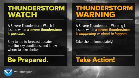
Severe Thunderstorm Watch: Be Prepared! Severe thunderstorms are possible in and near the watch area. Stay informed and be ready to act if a severe thunderstorm warning is issued. The watch area is typically large, covering numerous counties or even states.

Severe Thunderstorm Warning: Take Action! Severe weather has been reported by spotters or indicated by radar. Warnings indicate imminent danger to life and property. Take shelter in a substantial building. Get out of mobile homes that can blow over in high winds. Warnings typically encompass a much smaller area (around the size of a city or small county) that may be impacted by a large hail or damaging wind identified by an NWS forecaster on radar or by a trained spotter/law enforcement who is watching the storm.

CLICK HERE FOR GRANBURY'S WEATHER FORECAST

Share on Facebook
Share on Twitter
Share via Email

Copyright © 2023 City of Granbury. All Rights Reserved.
116 W. Bridge St. Granbury, TX 76048

Powered by
CivicSend - A product of CivicPlus